

Post by yenilira on Nov 26, 2011 1:45:33 GMT 1
Up in them thar hills, approximately 320 miles north-east from Alanya, taking the D400, then the D695/D696 to Konya, and the D300, you eventually arrive at the region that is “Cappadocia” or 'Kapadokya' in Turkish, which is contained within the provinces of Aksaray, Nevþehir, Nigde, Kayseri and Kirsehir in the Central Anatolian region, with its strange rock formations and unusual dwellings, an area roughly the size of Switzerland.
Located southwest of the major city Kayseri, which has airline and railway service to Ankara and Istanbul, and north-east of Konya, because of its location, Cappadocia was an extremely critical and strategic region. As Cappadocia's trade and resources were tempting prizes - the area is also famous for its carpet-weaving, wines and the distinctive red pottery - it was frequently invaded, raided, and looted.
To protect themselves from such depredations, the local inhabitants took to living in the region's caverns and grottos whose entrances could be concealed, so as not to be noticed by trouble-making outsiders. Since it might have been necessary to lie low for extended periods of time, these troglodytic dwellings eventually became subterranean cities that included sources of water, places to store food, wineries, and temples.
Some of them date back to before the Christian era.
And what else is there to see here?
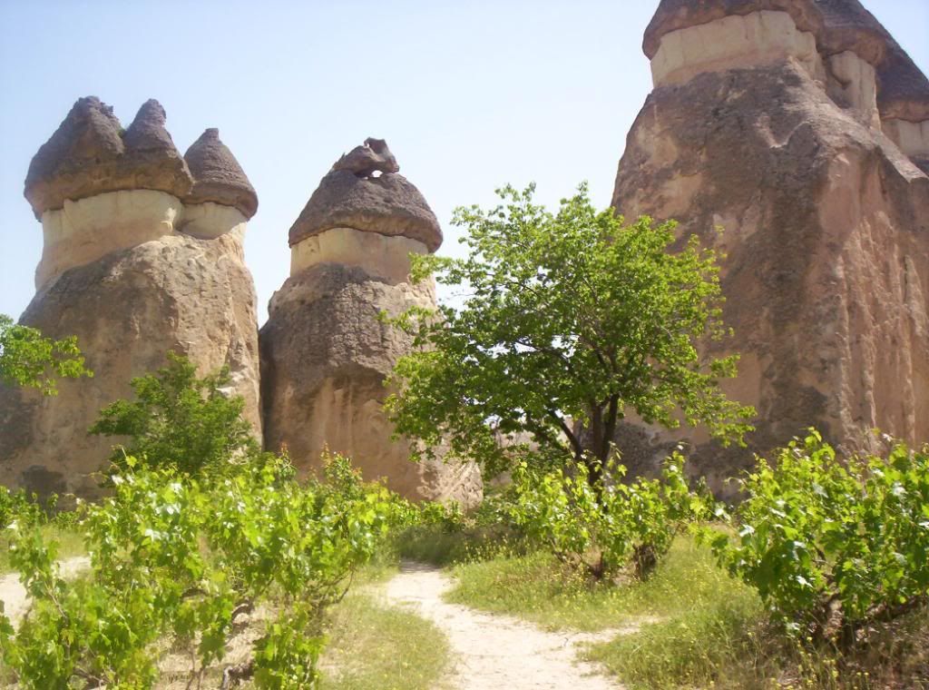
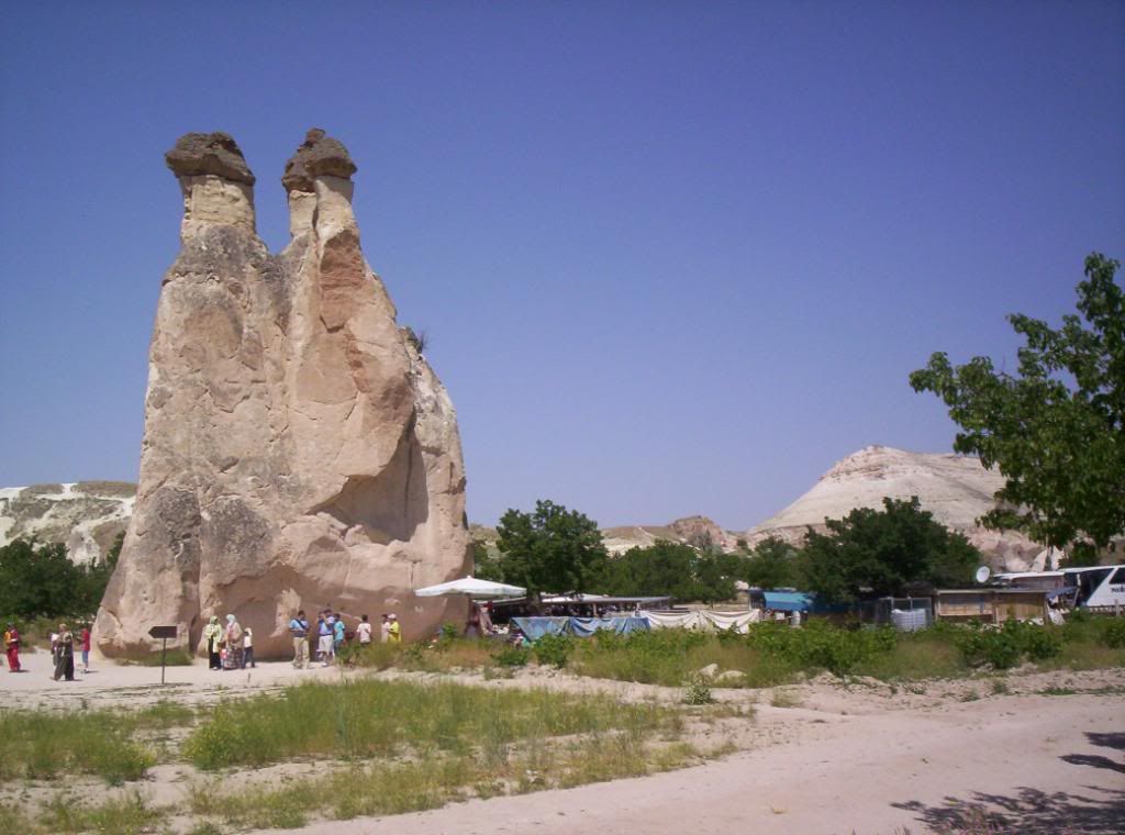
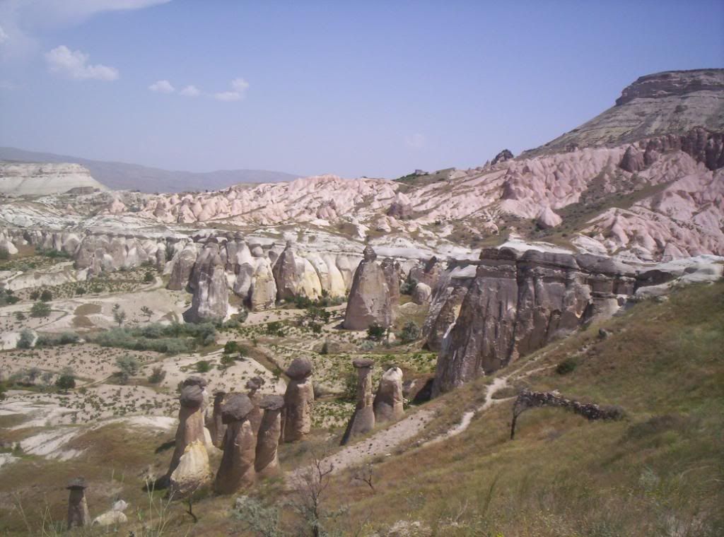
First and foremost, the “Peribacalar (peri bacalarý)” the world-reknown, unique and fascinating, “Fairy Chimneys” which are natural rock formations caused by volcanic eruptions followed by centuries of erosion of the rock surrounding the volcanic basalt.

Ürgüp (pop. 15,000), famous for its wines, has traditionally been the tourism center of the region, with many fine old houses of carved Cappadocian stone. The soft volcanic tufa lends itself to carving for decoration and to expansion: if the house needs a new room, the residents merely hollow one out of the hillside into which the house is built. The town has many fine inns with cave rooms such as the 'Esbelli Evi', as well as cheaper pensions.
Then there is www.cappadociacavesuites.com/en/index.asp?lang=en
Güzelyurt (which translates as 'Beautiful Home') has its own small underground city beneath the town center, several churches converted to mosques, and a dramatic setting beneath the snow-capped summit of Hasan Daðý.
With "fairy chimney" pinnacles of volcanic rock rising right in the town center, and cave houses in the valley walls, Göreme is a worthy rival to nearby Ürgüp, five miles away.
The Göreme National Park (“Göreme Milli Parklar” in Turkish) was added to the UNESCO World Heritage List in 1985, and contains the greatest concentration of rock-cut chapels and monasteries in the region.
The Kizlar Monastery is where the monks lived and worked: www.cappadociaonline.com/kizlar.html
The Yilanli Church (“Yilanli Kilise”) with its painted panels devoted to a number of Saints -
www.pbase.com/dosseman/snakechurch
The “Elmalý Kilisesi” or 'Apple Church' was carved into a hill with frescoes dating from the 11th Century. In the central apse we see represented Virgin Mary, Saint John the Baptist and Jesus Christ enthroned, and to the right of the altar, the 'Last Supper'.
The name of the church is believed to refer to a reddish orb in the left hand of the Archangel Michael in the dome of the main apse, or possibly to an apple tree that grew in the vicinity.
Tokalý Kilise (or the Church of the Buckle), is the largest church in Göreme. Restoration of the church was completed during the 1980s and one noted feature of the church is the main nave containing ninth century frescoes in "provincial" style. www.izlesene.com/video/tokali-kilisekapadokyamorg/317322
Güvercinlik Vadisi ('Pigeon Valley') lies between Göreme and Uçhisar and, as the name suggests, comprises of thousands of pigeon houses (dovecotes) which are carved into the soft tufa and the valley must have one of the greatest collections of dovecotes in the world. In Cappadocia, pigeons have long been a source of food and fertilizer.
Gümüþler Monastery, (10 km from Niðde in the village of Gümüþler). Spectacular monastery carved in rock, hidden from the outside world.
Dated at 10-11th century and only recovered in the 1960s. The monastery has some well preserved frescoes, including the only smiling (Mona Lisa style) Madonna in the world.
One of the most popular activities of the region - www.flickr.com/photos/hopemeng/4258450840/
(one starts at sunrise).
“Erciyes Daðý” - Mount Erciyes – an extinct volcano, at a height of 12,800plus feet, dominates Cappadocia, and is well respected by the locals due to its role in formulating the landscape when it buried the area in volcanic dust and ash millions of years ago.
“Cappadocia” means 'Land of Beautiful Horses' – we didn't see that many, if any, -
but you can view the valley atop a camel on guided tours.
The three of us (wife, granddaughter, and self) stayed at the 'Hotel Taskin' in Ürgüp for two nights BB&D with fifteen others on our coach, had the 'Swirling Dervish' show on the second, stopped off at Ýrmasan Geçidi which is the highest road point of the D695 at 1,525m. and the Mevlâna Müzesi in Konya on the way up, all for a total of £97. (June 2006).
Not forgetting a visit to an onyx 'factory'..........
Located southwest of the major city Kayseri, which has airline and railway service to Ankara and Istanbul, and north-east of Konya, because of its location, Cappadocia was an extremely critical and strategic region. As Cappadocia's trade and resources were tempting prizes - the area is also famous for its carpet-weaving, wines and the distinctive red pottery - it was frequently invaded, raided, and looted.
To protect themselves from such depredations, the local inhabitants took to living in the region's caverns and grottos whose entrances could be concealed, so as not to be noticed by trouble-making outsiders. Since it might have been necessary to lie low for extended periods of time, these troglodytic dwellings eventually became subterranean cities that included sources of water, places to store food, wineries, and temples.
Some of them date back to before the Christian era.
And what else is there to see here?
First and foremost, the “Peribacalar (peri bacalarý)” the world-reknown, unique and fascinating, “Fairy Chimneys” which are natural rock formations caused by volcanic eruptions followed by centuries of erosion of the rock surrounding the volcanic basalt.
Ürgüp (pop. 15,000), famous for its wines, has traditionally been the tourism center of the region, with many fine old houses of carved Cappadocian stone. The soft volcanic tufa lends itself to carving for decoration and to expansion: if the house needs a new room, the residents merely hollow one out of the hillside into which the house is built. The town has many fine inns with cave rooms such as the 'Esbelli Evi', as well as cheaper pensions.
Then there is www.cappadociacavesuites.com/en/index.asp?lang=en
Güzelyurt (which translates as 'Beautiful Home') has its own small underground city beneath the town center, several churches converted to mosques, and a dramatic setting beneath the snow-capped summit of Hasan Daðý.
With "fairy chimney" pinnacles of volcanic rock rising right in the town center, and cave houses in the valley walls, Göreme is a worthy rival to nearby Ürgüp, five miles away.
The Göreme National Park (“Göreme Milli Parklar” in Turkish) was added to the UNESCO World Heritage List in 1985, and contains the greatest concentration of rock-cut chapels and monasteries in the region.
The Kizlar Monastery is where the monks lived and worked: www.cappadociaonline.com/kizlar.html
The Yilanli Church (“Yilanli Kilise”) with its painted panels devoted to a number of Saints -
www.pbase.com/dosseman/snakechurch
The “Elmalý Kilisesi” or 'Apple Church' was carved into a hill with frescoes dating from the 11th Century. In the central apse we see represented Virgin Mary, Saint John the Baptist and Jesus Christ enthroned, and to the right of the altar, the 'Last Supper'.
The name of the church is believed to refer to a reddish orb in the left hand of the Archangel Michael in the dome of the main apse, or possibly to an apple tree that grew in the vicinity.
Tokalý Kilise (or the Church of the Buckle), is the largest church in Göreme. Restoration of the church was completed during the 1980s and one noted feature of the church is the main nave containing ninth century frescoes in "provincial" style. www.izlesene.com/video/tokali-kilisekapadokyamorg/317322
Güvercinlik Vadisi ('Pigeon Valley') lies between Göreme and Uçhisar and, as the name suggests, comprises of thousands of pigeon houses (dovecotes) which are carved into the soft tufa and the valley must have one of the greatest collections of dovecotes in the world. In Cappadocia, pigeons have long been a source of food and fertilizer.
Gümüþler Monastery, (10 km from Niðde in the village of Gümüþler). Spectacular monastery carved in rock, hidden from the outside world.
Dated at 10-11th century and only recovered in the 1960s. The monastery has some well preserved frescoes, including the only smiling (Mona Lisa style) Madonna in the world.
One of the most popular activities of the region - www.flickr.com/photos/hopemeng/4258450840/
(one starts at sunrise).
“Erciyes Daðý” - Mount Erciyes – an extinct volcano, at a height of 12,800plus feet, dominates Cappadocia, and is well respected by the locals due to its role in formulating the landscape when it buried the area in volcanic dust and ash millions of years ago.
“Cappadocia” means 'Land of Beautiful Horses' – we didn't see that many, if any, -
but you can view the valley atop a camel on guided tours.
The three of us (wife, granddaughter, and self) stayed at the 'Hotel Taskin' in Ürgüp for two nights BB&D with fifteen others on our coach, had the 'Swirling Dervish' show on the second, stopped off at Ýrmasan Geçidi which is the highest road point of the D695 at 1,525m. and the Mevlâna Müzesi in Konya on the way up, all for a total of £97. (June 2006).
Not forgetting a visit to an onyx 'factory'..........


 and then u woke up lol xx


 ? Xx
? Xx